ABSTRACT
In the past, variations in the chemical
contents (SO4
2−, Cl−, cations) of
crater lake water have not systematically demonstrated any
relationships
with eruptive activity. Intensive parameters (i.e., concentrations,
temperature, pH, salinity) should be converted into extensive
parameters
(i.e., fluxes, changes with time of mass and solutes), taking into
account
all the internal and external chemical–physical factors that affect the
crater lake system. This study presents a generalized box model
approach
that can be useful for geochemical monitoring of active crater lakes,
as
highly dynamic natural systems. The mass budget of a lake is based on
observations of physical variations over a certain period of time: lake
volume (level, surface area), lake water temperature, meteorological
precipitation, air humidity, wind velocity, input of spring water, and
overflow of the lake. This first approach leads to quantification of
the
input and output fluxes that contribute to the actual crater lake
volume.
Estimating the input flux of the "volcanic" fluid (Qf - kg/s) –– an
unmeasurable subsurface parameter –– and tracing its variations with
time is the major focus during crater lake monitoring. Through
expanding
the mass budget into an isotope and chemical budget of the lake, the
box
model helps to qualitatively characterize the fluids involved. The
(calculated) Cl− content and dD ratio of the rising "volcanic" fluid
defines
its origin. With reference to continuous monitoring of crater lakes,
the
present study provides tips that allow better calculation of Qf in the
future.
At present, this study offers the most comprehensive and up-to-date
literature review on active crater lakes.
For
the first time ever, samples were collected from volcanic lake waters
in Costa Rica using an unmanned aerial vehicle (drone), which
represents a major achievement in human–machine interaction and
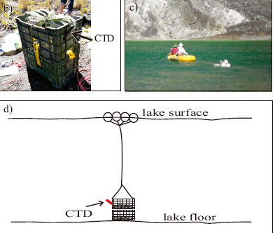
innovation in the technology sector. A Matrice 600 Pro drone was used
for remote sampling in the hyperacid crater lake of the Poás
volcano, the mildly acidic Lake Botos, and the nearly neutral Lake
Hule. A bailer bottle of 250 mL and a HOBO temperature probe, mounted
on the drone, were deployed using a specially designed delivery
retrieval system. A comparison was carried out relating to the
geochemistry of lake water collected by drone as opposed to the
hand-collected samples. The SO4−2/Cl
ratios of the two samples at Poás hyperacid crater lake were
similar, (1.1 ± 0.2) on average, an indication of a
lake with homogenous water composition. The Lake Hule showed a similar
composition to that registered 20 years ago. The waters from Lake Botos
showed some differences, which may be explained by the influence of
springs at the bottom of the lake, but the Wilcoxon's signed-rank test
showed a good exhibit of a satisfactory level of similarity. Autonomous
navigation proves to be very useful for faster, more efficient,
reliable, and less hazardous sampling of volcanic lakes.
Remote
sampling of water from Yugama crater lake at Kusatsu-Shirane volcano,
Japan, was performed using a drone. Despite the high altitude of over
2000 m above sea level, our simple method was successful in
retrieving a 250 mL sample of lake water. The procedure presented
here is easy for any researcher to follow who operates a drone without
additional special apparatus. We compare the lake water sampled by
drone with that sampled by hand at a site where regular samplings have
previously been carried out. Chemical concentrations and stable isotope
ratios are largely consistent between the two techniques. As the drone
can fly automatically with the aid of navigation by Global Navigation
Satellite System (GNSS), it is possible to repeatedly sample lake water
from the same location, even when entry to Yugama crater lake is
restricted due to the risk of eruption.
El
Chichón crater lake is characterized by important variations in
volume (40,000 m3to 230,000 m3)
and in chemical composition alternating between acid-sulfate and
acid-chloride-sulfate composition (Cl-/SO42-=
0-79 molar ratio). These variations in volume can occur very fast
within less than a few weeks, and are not always directly correlated
with the precipitation rate; the seepage rate of lake water is also an
important parameter to consider in the lake mass balance. In this
study, we present for the first time continuous physical data
(temperature, depth, precipitation, wind velocity, solar radiation) of
the crater lake registered by a meteorological station and two
dataloggers. A heat and mass balance approach is proposed to estimate
the heat and mass fluxes injected into the lake by the sublacustrine
fumaroles and springs. Tracing the evolution of such fluxes can be
helpful to understand this highly dynamic lake and offers an efficient
way of monitoring the volcanic activity. During the observation period,
the hydrothermal heat flux was estimated to be 17-22 MW, and the mass
flux 10-12 kg/s (error on both values of ± 15%). These fluxes
are mainly counterbalanced by the loss of heat and mass by evaporation,
respectively of 20-24 MW and 8-10 kg/s. Furthermore, the seepage rate
of the lake waters was estimated and shown to be a highly variable
parameter (12-42 kg/s), depending on the lake surface. This new data
set constitutes a baseline to monitor the future activity of El
Chichón volcano. In case of volcanic activity renewal, one of
the first precursor signals would probably be the full evaporation of
the lake.
Poás
Volcano is a complex stratovolcano in Costa Rica’s Central Mountain
Range and hosts acidic volcanic lakes. This study uses Unmanned Aerial
Vehicles (UAV) to monitor the physicochemical characteristics of the
hyperacid crater lake. Sampling was conducted in January and May of
2024, using a DJI Matrice 600 Pro equipped with a water collection
system. The results showed extremely low pH values (as low
as −1.04), high temperatures (up to 64 °C), and high
concentrations of sulfate (134 877 ppm) and chloride (88 434 ppm),
highlighting the influence of volcanic activity on the chemical
composition of the hyperacid lake water. Sampling was marked by a
decrease in rainfall patterns during the dry season and a reduction in
the lake’s water volume, indicating a high evaporation rate and the
release of gases and ash. The SO42−/Cl−ratio
was relatively constant, with no increase in activity and that meant
that it was safe for tourism, based on the physicochemical
characteristics of the hyperacid crater lake.
There
are hundreds of volcanic lakes around the world that represent an
important hazard due to the potential occurrence of phreatomagmatic or
limnic eruptions. Variations in geochemical and geophysical parameters
could help to identify potential risks for these events. Cuicocha and
Quilota volcanic lakes, located at the North Andean Volcanic Zone of
Ecuador, are geologically young, with gas emissions manifested mainly
as CO2via
bubbling gases. Both lakes present a limited monitoring record.
Therefore, volcanic monitoring is a priority task due to the potential
hazard they represent by the possibility of water stratification and CO2accumulation.
During 2012-2018 period, geochemical investigation based mainly on
diffuse CO2surveys
and analyzing the chemical and isotopic composition of bubbling gases
has been carried out at Cuicocha and Quilotoa lakes. Additionally,
vertical profiles of water columns were conducted in both lakes to
investigate the possibility of water stratification and CO2accumulation
in the lakes. A bathymetric study was also carried out in Quilotoa in
2017, giving further information about the degasification processes and
the morphology of the lake bottom. The computed diffuse CO2output
for Cuicocha volcanic lake (3.95 km2)
showed a range from 53 to 652 t d−1for
the period 2006–2018, with a maximum value in 2012, coinciding with a
maximum of the3He/4He
ratio measured at the bubbling gases and an increase in the seismic
activity with an episode of long-period seismicity recorded in
2011–2012. For Quilotoa volcanic lake (3.50 km2)
diffuse CO2output
was estimated between 141 and 536 t d−1for
the period 2014–2018. The chemical and isotopic data show that Cuicocha
has a chemical composition typical of worldwide superficial shallow
waters and aquifers, while Quilotoa shows a chemical composition
typical of crater lakes in active volcanic systems. The distribution of
the dissolved gas composition along the vertical profiles shows the
existence of different water masses in both lakes, with an increase in
the concentration of dissolved gases with depth. The carbon isotopic
signature indicates an endogenous origin of the CO2,
with a greater contribution in the stratification zone in both lakes.
This study shows methods applicable to other volcanic lakes of the
world to monitor their activity and potential risks.
Abstract
Three crater lakes from Mexican volcanoes were sampled and analyzed at
various dates to determine their chemical
characteristics. Strong differences were observed in the chemistry
among the three lakes: Nevado de Toluca, considered as
dormant, El Chicho´n at a post-eruptive stage, and
Popocate´petl at a pre-eruptive stage. Not surprisingly, no
influence of
volcanic activity was found at the Nevado de Toluca volcano, while the
other volcanoes showed a correlation between the
changing level of activity and the evolution of chemical trends. Low
pHs (,3.0) were measured in the water from the active
volcanoes, while a pH of 5.6 was measured at the Nevado de Toluca Sun
lake. Changes with time were observed at Popocate´petl
and El Chicho´n. Concentrations of volcanic-gas derived species
like Cl2, SO22
4 and F2 decreased irregularly at El Chicho´n
from 1983 until 1997. Major cations concentrations also diminished at
El Chicho´n. A 100% increase in the SO22
4 content was
measured at Popocate´petl between 1985 and 1994. An increase in
the Mg/Cl ratio between 1992 …Mg=Cl ˆ 0:085† and 1994
…Mg=Cl ˆ 0:177† was observed at Popocate´petl, before the
disappearance of the crater lake in 1994. It is concluded that
chemical analysis of crater lakes may provide a useful additional tool
for active-volcano monitoring.
Volcanic lake research boosted
after lethal gas burst occurred at Lake Nyos (Cameroon) in 1986, a
limnic rather than a volcanic event. This led to the foundation of the
IAVCEI-Commission on Volcanic Lakes, which grew out into a
multi-disciplinary scientific community since the 1990s. We here
introduce the first data base of volcanic lakes VOLADA, containing 474
lakes, a number that, in our opinion, is surprisingly high. VOLADA
could become an interactive, open-access working tool where our
community can rely on in the future. Many of the compiled lakes were
almost unknown, or at least unstudied to date, whereas there are acidiccrater lakestopping active
magmatic–hydrothermal systems that are continuously or discontinuously
monitored, providing useful information for volcanic surveillance
(e.g., Ruapehu, Yugama, Poás). Nyos-type lakes, i.e. those
hosted in quiescent volcanoes and characterized by significant gas
accumulation in bottom waters, are potentially hazardous. These lakes
tend to remain stably stratified in tropical and sub-tropical climates
(meromictic), leading to long-term build-up of gas, which can be
released after a trigger. Some of the unstudied lakes are possibly in
the latter situation. Acidiccrater lakesare
easily recognized as active, whereas Nyos-type lakes can only be
recognized as potentially hazardous if bottom waters are investigated,
a less obvious operation. In this review, research strategies are lined
out, especially for the “active crater lakes”. We make suggestions for
monitoring frequency based on the principle of the “residence time
dependent monitoring time window”. A complementary, multi-disciplinary
(geochemistry,geophysics,limnology,
statistics) approach is considered to provide new ideas, which can be
the bases for future volcanic lake monitoring. More profound
deterministic knowledge (e.g., precursory signals for phreatic
eruptions, or lake roll-over events) should not only serve to enhance
conceptual models of single lakes, but also serve as input parameters
in probabilistic approaches. After more than 25 years
of pioneering studies on rather few lakes (~ 20% of all), the
scientific community should be challenged to study the many poorly
studied volcanic lakes, in order to better constrain the related
hazards.
This newly-developed instrument monitors lava
lakedynamics with unprecedented
resolution. The CLR gauge autonomously measures lava lake
elevation in real time, using the light-reflecting properties of the
lava surface.
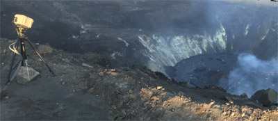
The
CLR gauge is stationed on the western
rim of Halemaʻumaʻu crater within a closed
area of Hawaiʻi Volcanoes National Park, under a
National Park Service permit. The instrument is aimed into the
crater at an inclination of 32.57 degrees
below the horizon. Current measurement range
is about 733 m (2405 ft).
The
CLR gauge transmits a laser pulse every
second. The 1550 nanometer wavelength
laser is invisible and eye safe. The
laser beam broadens with distance, making a target footprint
about 0.5 m (1.6 ft) diameter on the
lava lake surface near the previously active vents
on Halemaʻumaʻu’s northwest wall.