WWW.VOLCANICLAKES.COM
|
Methods for studying acidic
crater lakes.
|
Methods
for studying acidic crater lakes include chemical and isotopic analysis
of water and gas samples, in-situ measurements of water properties like
pH and temperature, hydroacoustic surveys to study gas bubble flux, and
remote sensing techniques like thermal imaging. Chemical modeling is
also used to understand the lake's geochemical processes and predict
potential hazards.
|
|
|
A
novel aquatic drone ventured into highly acidic waters to test the
feasibility of remotely exploring and surveying hazardous volcanic
lakes.
|
|
|
|
|
For
the first time ever, samples were collected from volcanic lake waters
in Costa Rica using an unmanned aerial vehicle (drone), which
represents a major achievement in human–machine interaction and
innovation in the technology sector. A Matrice 600 Pro drone was used
for remote sampling in the hyperacid crater lake of the Poás
volcano, the mildly acidic Lake Botos, and the nearly neutral Lake
Hule. A bailer bottle of 250 mL and a HOBO temperature probe, mounted
on the drone, were deployed using a specially designed delivery
retrieval system. A comparison was carried out relating to the
geochemistry of lake water collected by drone as opposed to the
hand-collected samples. The SO4−2/Cl
ratios of the two samples at Poás hyperacid crater lake were
similar, (1.1 ± 0.2) on average, an indication of a
lake with homogenous water composition. The Lake Hule showed a similar
composition to that registered 20 years ago. The waters from Lake Botos
showed some differences, which may be explained by the influence of
springs at the bottom of the lake, but the Wilcoxon's signed-rank test
showed a good exhibit of a satisfactory level of similarity. Autonomous
navigation proves to be very useful for faster, more efficient,
reliable, and less hazardous sampling of volcanic lakes. |
|
|
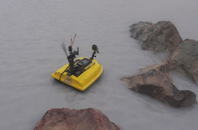
Field
Report: Autonomous Lake Bed Depth Mapping
by a Portable Semi-submersible USV at Mt. Zao Okama Crater Lake
|
Abstract— This work
presents a design and a field test
result of a small USV system that has portability and wind
tolerance for a lake bed depth mapping of volcanic crater
lakes. The depth map of the crater lakes indicates an amount
of water, crater wall caving, and volcanic upthrust, which is
used for volcanic disaster prevention. However, todayfs depth
surveillance is achieved by using a manned canoe on a lake in
high-altitude, strong-winded, and restricted areas. This research
is aiming to realize the autonomous Unmanned Surface Vehicle
(USV) for volcanic crater lake surveillance in reducing risks
to surveyors. In this research, the authors have developed the
lightweight semisubmersible USV system with a high draft that
has portability and wind tolerance. The result of a field test
at Mt. Zao Okama Crater Lake is shown. A depth map of
the north half of the Okama Crater Lake was autonomously
measured by using the USV system. |
|
|
Hydrochemical
and Hydroacoustic Investigation of the Yugama Acid Crater Lake,
Kusatsu-Shirane, Japan
|
The
gases dissolved in the waters of volcanic lakes can present a serious
hazard if the physical-chemical conditions change due to variations in
the supply of magmatic gases. The monitoring of gases such as CO2 and
He help us understand the degassing process and their connection with
magmatic/hydrothermal system. One of the most acidic volcanic lakes on
the planet is the Yugama, on Kusatsu Shirane volcano (Japan). We report
the results of an interdisciplinary study carried out in August 2013 at
Yugama consisting of the first estimation of rate of diffuse CO2 emission,
the chemical and isotopic analysis of water and dissolved gases in
samples from vertical lake profiles, and an echo-sounding survey. The
lake water has an average temperature of 24-25°C, pH 1.01,
concentrations of SO42- between
1,227 and 1,654 mgL−1 and
Cl− between
1,506 and 2,562 mgL−1,
with gas bubbling at several locations and floating sulfur globules
with sulfide inclusions. A total of 66 CO2 efflux
measurements were taken at the lake surface by means of the floating
accumulation chamber method to estimate the diffuse CO2 output
from the studied area. CO2 efflux
values ranged from 82 up to 25,800 g m−2 d−1.
Estimation of the diffuse CO2 emission
at Yaguma Crater Lake was 30 ± 12 t d−1.
Normalized CO2 emission
rate (assuming an area of 0.066 km2)
was 454 t km−2 d−1,
a value within the range of acid volcanic lakes. Vertical profiles of
major ions and dissolved gases showed variations with increases in ion
content and dissolved CO2 and
He with depth. Acoustic imaging shows the presence of intense bubbling
and provides important information on the bathymetry of the lake. The
50–200 kHz echograms exhibit frequent vertical plumes of rising
gas bubbles. Within the crater-lake, three circular submarine vents
have been identified showing flares due to a significant activity of
sublacustrine emissions. This work shows the first data of diffuse CO2 degassing,
dissolved gases in water and echosounding (ES) from Yugama Crater Lake.
Periodic hydrogeochemical and hydroacoustic surveys at Yugama Crater
Lakemay thus help to document changes in the state of activity of this
high-risk volcanic area. |
|
|
| Geochemical
monitoring of volcanic lakes. A generalized box model
for active crater lakes |
ABSTRACT
In the past, variations in the chemical contents (SO4
2−, Cl−, cations) of
crater lake water have not systematically demonstrated any
relationships
with eruptive activity. Intensive parameters (i.e., concentrations,
temperature, pH, salinity) should be converted into extensive
parameters
(i.e., fluxes, changes with time of mass and solutes), taking into
account
all the internal and external chemical–physical factors that affect the
crater lake system. This study presents a generalized box model
approach
that can be useful for geochemical monitoring of active crater lakes,
as
highly dynamic natural systems. The mass budget of a lake is based on
observations of physical variations over a certain period of time: lake
volume (level, surface area), lake water temperature, meteorological
precipitation, air humidity, wind velocity, input of spring water, and
overflow of the lake. This first approach leads to quantification of
the
input and output fluxes that contribute to the actual crater lake
volume.
Estimating the input flux of the "volcanic" fluid (Qf - kg/s) –– an
unmeasurable subsurface parameter –– and tracing its variations with
time is the major focus during crater lake monitoring. Through
expanding
the mass budget into an isotope and chemical budget of the lake, the
box
model helps to qualitatively characterize the fluids involved. The
(calculated) Cl− content and dD ratio of the rising "volcanic" fluid
defines
its origin. With reference to continuous monitoring of crater lakes,
the
present study provides tips that allow better calculation of Qf in the
future.
At present, this study offers the most comprehensive and up-to-date
literature review on active crater lakes. |
|
|
|
|
|
|
|
|
|
|
|
|
|
|
|
|
|
|
|
|
|
|
|
|
|
|
|
|
|
|